General information & Geological History
Dorset Geologists' Association Group
Pembroke Field Trip
2013
Click for higher resolution photos
click 'close' at base of photo
to return to this page

1 2
3 4
5 6
7 8
9 10
11 12
13 14

15 16
17 18
19
Tides are critical to access many of the listed sites and a falling spring tide is recommended. A number of the sites have cliffs so hard hats are recommended as are walking boots. The outline below was used for a DGAG weekend as well as a longer field trip with Suffolk U3A.
Recommended maps: O.S. Sheet 157 St. David's and Haverford West and O.S. sheet 158 Tenby and Pembroke. Also O.S. Explorer sheet OL35 North Pembrokeshire and OL36 South Pembrokeshire.
Day 1
Whitesands Bay G.R. SM733272. Basal Cambrian conglomerate with faulted boundary against Precambrian. Also Cambrian and Ordovician slates with bedding and cleavage. Evidence of soil creep in weathered cliff top material. Carn Lidi (G.R. SM738279), Porth Lleuog (G.R. SM732274) and Porthmelgan (G.R. SM728279) gabbro intrusion and Ordovician sediments.
St. Non's Bay G.R. SM752243. Faulted and unconformable contact between Precambrian and Cambrian strata. Precambrian volcanic agglomerate and Cambrian sediments.
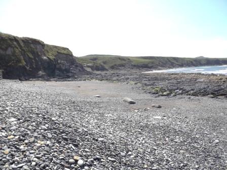
New Gale Beach. G.R. SN847222. An interesting collection of pebbles on beach of various origins. Good swash aligned beach linked to dominant waves. This provides an interesting example of the relationship between structure, rock type and landscape where the Cambrian is faulted against the Upper Carboniferous.
Abereiddi Bay. G.R. SM797313. On the south side of bay Ordovician Murchisoni Ash (volcanic) and Didymograptus murchisoni shales which are very fossiliferous in places occur. Moving north up the succession into Dicranograptus Shale and then down the succession again as the bay is in a synclinal structure.
Strumble Head. G.R. SM895413 sheet 157 St. David's and Haverford West. Spilites, pillow lavas and numerous rhyolitic lavas including rhyolitic breccias, agglomerates, flow banding and other lava structures and textures of Ordovician age. Some of the best pillow lavas are at Pen Anglas (GR SM 949406) just north of Fishguard but these are less accessible than those at Strumble Head.
Day 2
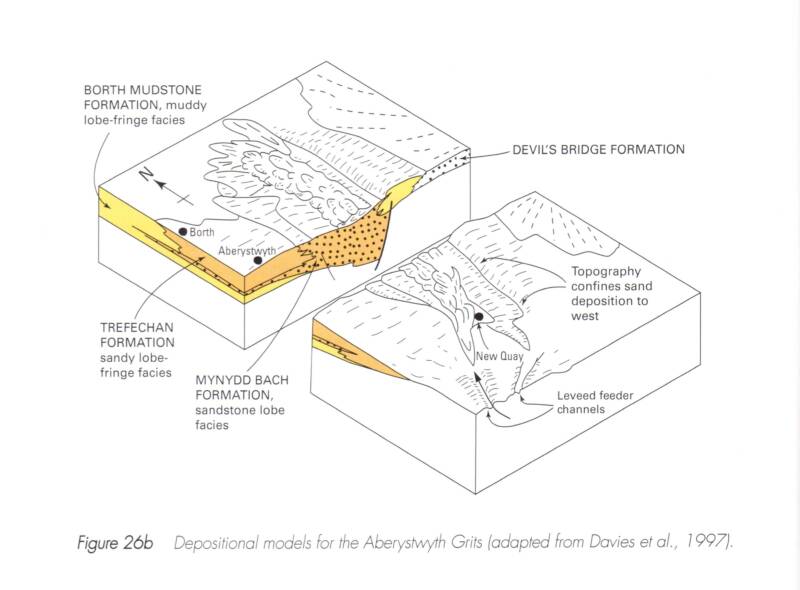
New Quay Sands. G.R. SN390600 (Sheet 145 Cardigan) and Aberaeron G.R. SN450625 to look at Silurian Aberystwyth Grits. Turbidite sedimentary sequence with graded bedding and flute casts in sandstones with inter-bedded shale / slates. Also Caledonian folding and faulting as well as the relationship between bedding and cleavage enabling way up to be determined in strongly deformed rocks.
Day 3
Elegug Stacks G.R. SS925945 with spectacular coastal scenery developed on folded Carboniferous Limestone (depends on access to Castle Martin Firing Range’ phone 01646 662367 for information).
Freshwater West G.R. SR884997 Succession of Devonian Old Red Sandstone sediments moving up from the Silurian but Silurian sediments are not normally exposed. Stackpole Quay G.R. SR994958 with complex folding and faulting in the Carboniferous Limestone. Mapping exercise can be carried out here if tide conditions are suitable. Unfortunately the Devonian / Carboniferous boundary is not accessible north of Stackpole Quay but can be seen around G.R. 995961.
West Angle Bay G.R. SN853033 p.m. on a falling tide. Succession includes Carboniferous Avon Group (Lower Limestone Shale) and Black Rock Limestone. Folded into a syncline with faulting and other minor folds exposed in wave cut platform on the beach.
Marloes Sands. G.R. SR782075 Silurian and Old Red Sandstone succession - spectacular cliffs with vertical dips.
Day 4
Saundersfoot G.R. SN137046 towards Monkstone Point G.R. 150032 O.S. Sheet 158 Tenby. Upper Carboniferous sediments with sedimentary and tectonic structures with Coal Measures plant fossils.
Amroth GR SN162070
Broadhaven G.R. SN860140 O.S. Sheet 157. This shows Coal Measures (U. Carboniferous) with good Variscan structures. The traverse will extend at least as far as the Sleek Stone G.R. 858144 but depends upon tides for access. We can use cliff path to gain access to some areas.
Day 5. Return home, stopping off at Friars Point (G.R. ST11660 0.S. Sheet 171 Cardiff and Newport). Study of unconformity between Carboniferous Limestone and Triassic breccia and succession up into Lower Jurassic. Tides here should not be an issue.
Alan Holiday April 2013.

20
21
22 23


24 25
26 27
28 29
30 31

32 33

34 35
36
D E
A
B
C
F

37 38
39 40
41 42
Geological background for DGAG South Wales Field Trip.
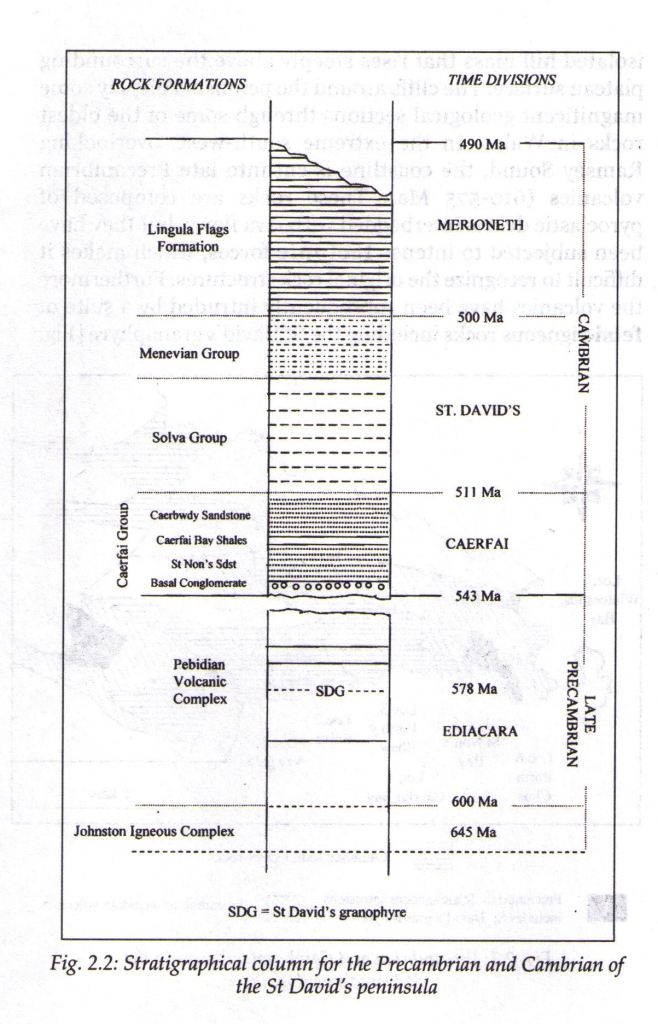
Cambrian 541 - 485 m.a. (see reference 1 at end for dates): the first geological period (a 2nd order geological time unit) of the Phanerozoic (time from Cambrian to present in which sedimentary rocks have obvious life i.e. fossils). The Cambrian is also part of the Palaeozoic (an era – a 1st order geological time unit). Rocks deposited in Cambrian period (time) form the Cambrian system. Obvious life consisted of various invertebrate groups (organisms with shell or external test / carapace) especially trilobites and brachiopods although most of the major groups evolved during the Cambrian. Organisms evolved with hard parts which favoured fossilisation. Trilobites act as zone fossils in the Cambrian (organisms which allow division of succession into ‘short’ time periods linked to rates of evolution).
The Cambrian is based on type area of Cambrian Mountains in N. Wales and was first proposed by Adam Sedgewick in 1835.
Distribution: rocks of Cambrian age in UK are found in S.W. Wales (St David’s), N. Wales (Llanberis), isolated inliers (older rocks surrounded by younger rocks) in the Midlands, also N.W. Scotland to N & W of Moine Thrust. Significant areas of what were Cambrian rocks have been altered by metamorphism (Caledonian Orogeny) e.g. Grampian Highlands.
Palaeo-geography: The Cambrian started with a marine transgression (widespread rise in sea level). This flooded the land (Precambrian land surface) forming extensive continental shelf sea areas (water < 200 m. deep). Evidence for this can be seen at Whitesands Bay and St. Non’s Bay on the St David’s Peninsula. The marine transgression was due to:
(a) The melting of late Precambrian ice sheets which were very extensive, allowing water to be displaced on to the land.
(b) Warming of the Earth caused expansion of sea water taking up more volume (?).
(c) New ocean(s?) forming especially the Iapetus Ocean between Scotland / N. Ireland and England / Wales / S. Ireland. Ocean ridges displace water on to the land.
The global rise in sea level favoured an explosion of life because of opportunities for organisms in ecological niches on the continental shelf. The sea extended over stable cratonic blocks to the north and south of Iapetus Ocean. These were then relatively unaffected by later earth movements associated with the Caledonian Orogeny when the Iapetus Ocean closed at the end of the Silurian.
During the Cambrian, the Iapetus Ocean was opening as there is no clear evidence of subduction with island arc volcanism in the geological succession in the UK. (There might have been some in the Dalradian rocks of Scotland which have been affected by regional metamorphism and this disguises the original rock material.)
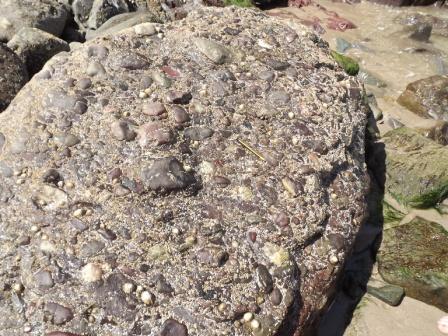
As the transgression continued the sea got deeper and sediment type changed from shallower water (conglomerate and quartz arenite i.e. quartz rich sandstone) to deeper water (shales). Examples of successions are seen at Whitesands Bay (St David’s), Welsh Borderland (Wrekin), Llanberis (N. Wales) and N.W. Scotland (Durness). Initially the transgression may have been rapid with conglomerate (rudaceous sediment with rounded clasts > 2 mm) e.g. at Whitesands Bay - poorly sorted (based on physical characteristics of uniformity of shape and size and uniformity of chemistry), immature (the conglomerate has clasts with a wide range of size, sub-angular through to sub-rounded and very varied chemistry), polymictic (clasts of more than one type). The clasts are derived from the underlying Precambrian rocks and this demonstrates the Law of Included Fragments (clasts making up a younger rock must be made from material derived from an older rock as shown by unconformable sequences) and the Law of Superposition of Strata (strata on top are younger / more recent than strata underneath in an undisturbed succession). The sediment from the Wrekin (Welsh Borderland) is a quartz arenite (an arenaceous sediment with sand size (particles <2 mm->0.06 mm and a rock which is >95% silica with quartz grains and a silica cement). This is a well-sorted, very mature sediment due to sorting by long periods of wave action. The rocks from the initial marine transgression have few, if any fossils, as the sediment deposited on the coastline where wave action would have been strong destroying any shelly organisms before they could be preserved - i.e. a high energy environment. The different sediments forming the base of the Cambrian could be because the sea level rose at different rates. There was initially a rapid rise e.g. at Whitesands Bay and then slowed down e.g. the Wrekin (Shropshire). At St. Non’s Bay poorly sorted sandstone occurs above the basal conglomerate suggesting a rapid rise in sea level limiting the degree of sorting. The sediments deposited by this extensive marine transgression are not all of the same age and the horizon is said to be diachronous (literally across time).
The difference in sediment type of similar age from place to place is called facies variation because of different environments of deposition at each of the localities - St. David’s and Wrekin shallower water. (In North Wales at Llanberis deeper water fine grained sediments have been converted into the world famous slate).
Fossils. The Cambrian fauna is dominated by trilobites and brachiopods but the fauna in England and Wales differs from that in NW Scotland (different faunal provinces) due to the presence of the Iapetus Ocean at the time. The organisms were largely benthonic (living on the sea floor) and couldn’t cross the deep ocean. This is one of the lines of evidence for the presence of the Iapetus Ocean. Trilobites were vagrant (crawling over the sea floor) while the brachiopods were sessile as an epifauna (attached to the sea floor) or an infauna partially buried in sediments e.g. (Lingula).
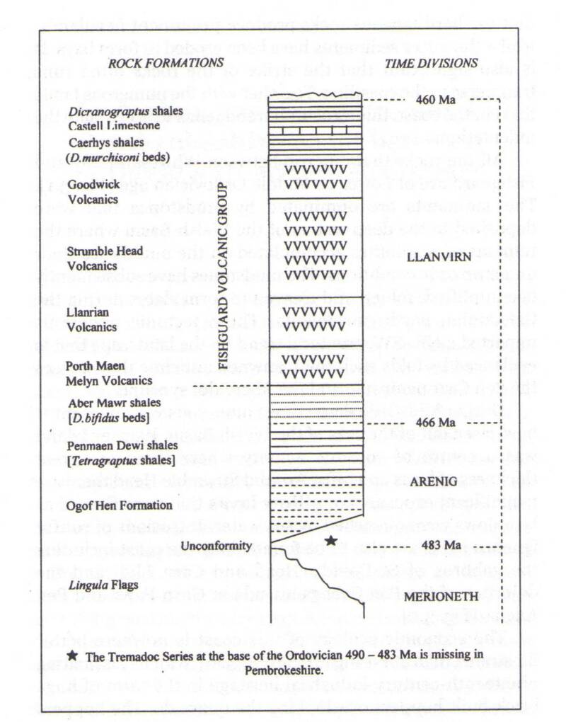
Ordovician 485-443 m.a. Many features of the Cambrian continued into the Ordovician i.e. the presence of the Iapetus Ocean, shelf sea sedimentation, deeper basins with shales and turbidites, facies variation. The Ordovician was proposed by Lapworth following argument between Sedgewick and Murchison over the boundary of the Cambrian and Silurian.
The Cambrian Ordovician boundary is marked by a small angular unconformity due to earth movement and a relative fall in sea level.
The Iapetus Ocean started to close by subduction (the more dense oceanic plate material pushed down into the mantle while the less dense continental crust remains at the earth’s surface) in the Ordovician indicated by extensive volcanism. This is best displayed in the Lake District, North Wales (e.g. around Snowdon) and South Wales (e.g. Strumble Head). These were part of island arcs (chains of volcanoes close to subducting plate margins) formed on the non-subducting plate margin. The volcanicity was mostly explosive typical of modern subduction zones with thick accumulations of ash (tuff), nuée ardente (forming welded tuff from fused lava droplets) and pyroclastic flows (mixture of ash and pumice). Relatively small amounts of andesitic lavas formed (fine grained intermediate igneous rock with 52 - 65% silica). The type of lava erupted can vary from rhyolite (acid with > 65% silica) to basalt (basic with 45 - 52% silica) due to fractionation of the magma in the magma chamber (separation into magmas of different composition based on density). The first erupted is more acid, last erupted more basic. Because of this pillow lavas may be present e.g. at Strumble Head. The ash may show graded bedding (coarser material at the base of a unit, deposited first, and finer material at top, deposited last, allowing way up to be determined (whether sequence is right way up or inverted by folding linked to earth movements). Grading can also occur laterally as well as thickness of deposits. Pillow lava structures can also demonstrate way up as the molten lava sags down between earlier flows. This is well demonstrated on the coast between Strumble Head and Fishguard. Chert was deposited associated with the volcanic material and was possibly precipitated from the sea water (due to changes in pH) or associated with siliceous organisms in the sea water e.g. radiolaria.
Facies variation is well demonstrated in the Ordovician with shallow marine sediments in the Midlands (dominated by brachiopods and trilobites) and deeper water sediments in mid Wales and S.W. Wales e.g. Abereiddi Bay - graptolitic shales (thinly bedded mud rock). Graptolites act as zone fossils for the Ordovician with multi-stiped and biserial forms. They are useful because they evolved rapidly, are numerous, are easily recognised but they are fragile and are facies dependent being rarely preserved in coarser clastic sediments. They were also carried by ocean currents being planktonic organisms (floating) so occur in gyres (large oceanic circulation systems) and are not dispersed globally. The graptolitic shales can be inter-bedded with volcanics associated with the island arc volcanism linked to subduction. Fossils provide evidence for the closing of Iapetus as faunas on either side of the ocean start to be similar in Ordovician - planktonic organisms were able to cross the ocean while benthonic ones were not. There is little evidence of fauna apart from graptolites at Abereiddi Bay suggesting that the bottom conditions were anoxic (oxygen deficient). The dark colour of the shale suggests that finely disseminated pyrite is present or high levels of preserved carbon. Elsewhere, e.g. in Shropshire shallower seas existed with an abundant benthonic fauna.
Silurian 443-419 m.a.
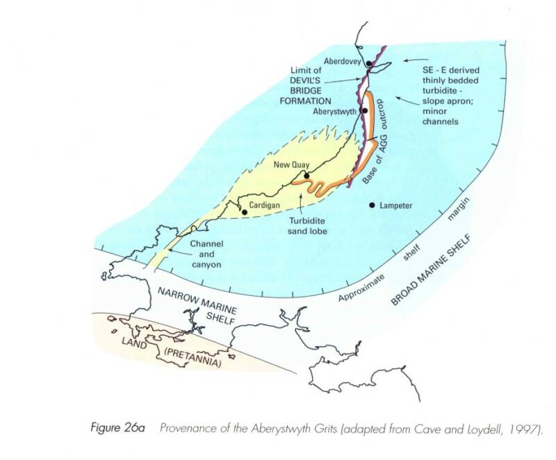
The Silurian continued sedimentation patterns of the Ordovician. Silurian sediments in Mid Wales are flysch sediments which were deposited as turbidites in a subsiding sedimentary basin but eventually filling up as compressive forces caused uplift (Caledonian Orogeny). Such flysch sediments are seen at New Quay Sands and Aberaeron in the form of the Aberystwyth Grits. Well-developed graded bedding occurs with coarse sediment, occasionally > 2 mm (i.e. gravel), but normally gritty sands, becoming finer into silts at the top. These are inter-bedded with mudstones. They also develop sole marks which are in-filled with sediment to form flute casts. Convolute bedding is sometimes seen where de-watering of the sediments occurred disrupting the laminations in the fine grained sediments. All these are useful for determining way up which is important as the beds show complex folding. The numerous turbidity flows were triggered by earthquakes linked to tectonic movements on the margins of the Iapetus Ocean. Newly deposited, unconsolidated sediment flowed down slope over the sea floor finally creating greywacke sandstone inter-bedded with mudstone.
Good facies variation is developed as the Silurian further south west, as seen at Marloes Sands, includes shallow marine sediments. These contain more clastic sediment than those deposited farther east in the UK such as around Wenlock famous for its fossiliferous limestone. The sandstones and calcareous mudstones exposed at Marloes contain brachiopods and corals, the brachiopods having been used to provide evidence of water depth in Lower Silurian times (Llandovery). Zonation of the Silurian is based largely on graptolites especially monograptids, which are uniserial with a single stipe, and varying form of thecae. Some multi-stiped forms developed towards the end of their existence (early Devonian).
During Ordovician and Silurian continental collision processes with final closure of the Iapetus Ocean occurred. Closure was complex with closure perpendicular but later transverse movement limiting the tectonic impact on the Silurian rocks especially in England and Wales. This helps to explain why there was limited Silurian volcanism in the British Isles i.e. limited subduction so limited volcanism. The join between two sides of Iapetus is suture line and more or less coincides with England Scotland Border.
As Pembrokeshire is located well to the south of the collision zone evidence of the tectonic events is limited to folding and faulting. The fold trends seen are typically NE/SW and are particularly well displayed at New Quay Sands and Aberaeron. Other features of the tectonics are poorly developed in Pembrokeshire although the mudstones deposited often develop a slatey cleavage, another method of determining way up. If the dip of the cleavage is greater than the dip of the strata, the beds are the right way up, if the dip of the cleavage is shallower than the dip of the strata, the beds are overturned/inverted.
With the orogeny, tectonic uplift occurred resulting in a marine regression – i.e. a sea-level fall. This is well developed in the sediments at Marloes Sands and Freshwater West where there is a change from marine sediments in the earlier Silurian to continental deposits in the later Silurian and Devonian. The change from marine to continental is now considered to have occurred at around 424 m.a. before the end of the Silurian.
The Old Red Sandstone is the name given to the continental facies of the Devonian. However in some places the Old Red sandstone facies came in at the end of the Silurian so Old Red Sandstone and Devonian are not synchronous. The boundary is therefore diachronous. Sediments are maroon red in colour indicating more humid continental conditions (bright orange red occurs in the Permo-Triassic (New Red Sandstone) with the arid conditions). The Silurian Devonian boundary in England and Wales is often conformable but a marked angular unconformity occurs elsewhere in the UK.
The O.R.S. sediments vary from very coarse conglomerates in Scotland and N. Ireland to generally finer fluvial sediments as seen at Freshwater West in Pembrokeshire. (There are some v. coarse sediments at the base of the succession at Freshwater West and also in the succession at Marloes Sands). These show significant variation in lithology with good sedimentary structures - ripple cross-bedding etc. Rivers flowed south and some sediments contain evidence of exotic minerals such as garnet suggesting erosion of Dalradian metamorphics in Scotland. These occur in the L. O.R.S. They are not seen in the later U. O.R.S. suggesting the distant source had gone due to uplift of intervening area. M. O.R.S. is largely absent in England and Wales (although dating is difficult) but is present in N.E. Scotland – e.g. intermontane basins deposits e.g. Achanarras Caithness Flags with fish fossils - flagstone - micaceous sandstone making it fissile.
Scotland
Caithness
eg Thurso
M ORS in
intermondane
basins
L ORS
coarse clastic
molasse sediments
Unconformity
Precambrian
metamorphics
Scotland
Central Valley
eg Alloa
ORS
sediments &
volcanics
no base seen
Scotland
Southern Uplands
eg Hutton
Unconformity
Coarse clastic
sediments
Unconformity
steeply dipping
Silurian sediments,
turbidites
Welsh
Borderland
& South Wales
eg Marloes Sands
Coarse clastic
sediments
Alluvial plain-feldspathic
sandstones
Tidal-Ludlow
Bone Bed
No unconformity apparent
Marine
Silurian
sediments
North Devon
eg Ilfracombe
Alternating
continental
and marine sediments
no base seen
South Devon
eg Torquay
Marine sequence
with coral limestones and
fossiliferous mudstones
no base seen
o
Detail for localities for Pembrokeshire Field Trip day 1
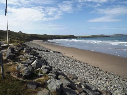
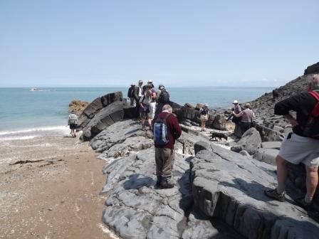
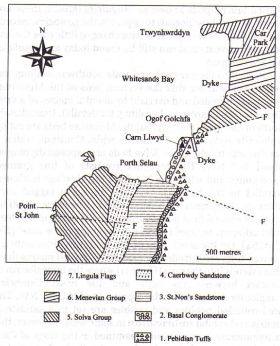
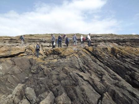
Whitesands Bay G.R. SM733272 O.S. Sheet 157 St. David's and Haverford West.
According to tidal conditions work south from the car park at the end of the road from St David’s.
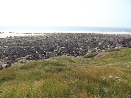
(picture 1 – general view of Whitesands Bay looking SW))
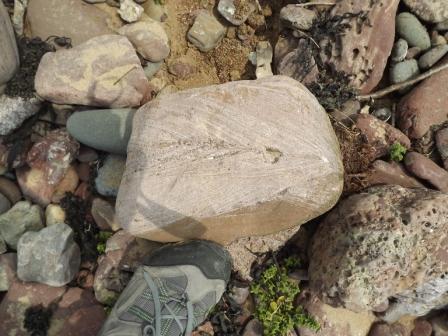
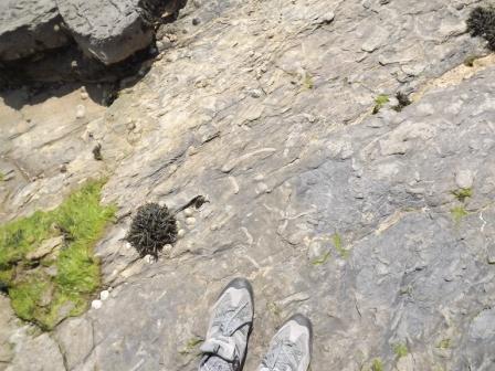
To the north of the car park is the Lingula Flags Formation (Upper Cambrian). These dip to the north at around 70 . They consist of sandstones, flagstones (fissile sandstone) and mudstone. Quartz veins from sweating out are common in the sandstone units. Sedimentary structures such as cross-bedding, graded bedding and load casts can be seen indicating way up. Some of the mudstone units show evidence of Lingulella davisii and these are one of the first organisms to be commonly preserved in the geological record. Lingulella can be found today in coastal waters around Japan and have change little over the last 500 m.a. (Figures A are from Folds, Faults and Fossils: exploring geology in Pembrokeshire by John Downes)
The environment of deposition was probably a tidal / inter-tidal environment similar to that which Lingulella lives in today.
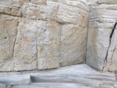
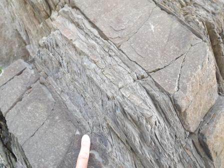
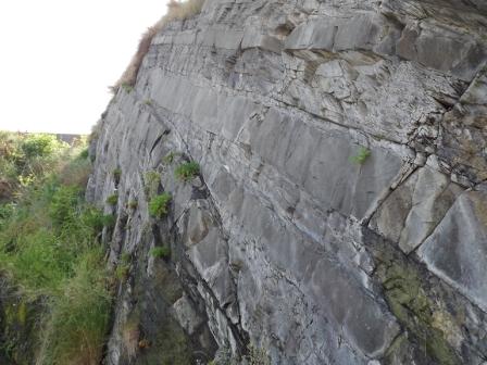
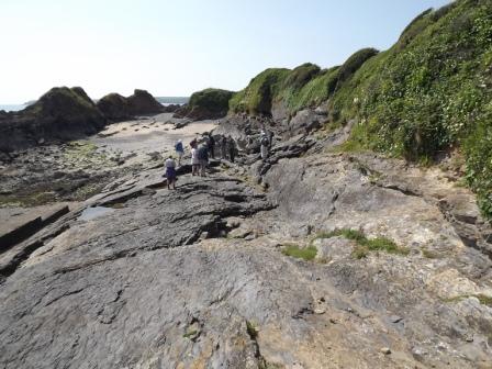
Working south from the car park (working down the succession) Menevian Group beds are exposed covered by peri-glacial head and possibly raised beach material. These beds are cut by a 10m wide dolerite dyke to the north of some steps. The Solva Beds are exposed further south and the material is fine grained sandstone and siltstone with well-developed cleavage and these shows evidence of micro-folding. (picture 2)
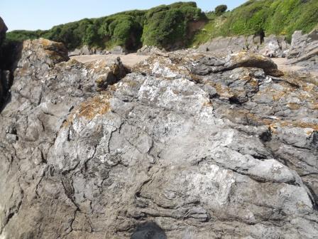
Green sandstone units are exposed further south and some contain cubic pyrite crystals. This feature is not mentioned in references sources so detail of their origin is not known (by me!) (picture 3). However the cubes must have grown in the sediment prior to lithification as there is no evidence of deformation around the cubes. On the wave washed surfaces good evidence of dip and cleavage is apparent. On the cliff top good evidence of soil creep is apparent with the ends of the beds being turned over down slope picture 4).
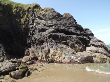
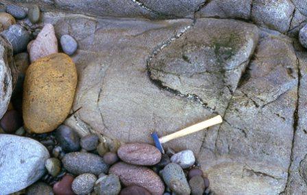
In the far south of the bay at Ogofgolcha the basal conglomerate of the Caerfai Group is exposed (pictures 5 & 6). The situation is complex with folding and faulting. However this is an excellent example of a basal conglomerate unconformably resting on Precambrian volcanics and sediments.
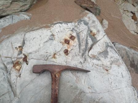
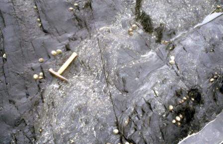
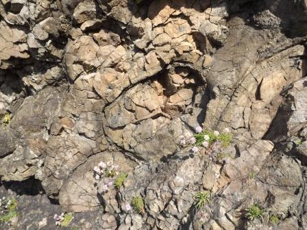
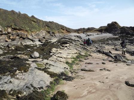
Abereiddi Bay G.R. SM797313. O.S. Sheet 157 St. David's and Haverford West. Take the minor road from the A487 St David’s to Fishguard road at Croes-goch parking just above the beach (picture 7). The strike of the beds here is more or less E/W not the typical NE/SW for rocks affected by the Caledonian Orogeny. Abereiddi Bay is eroded in an overturned syncline developed in mudstones of Llanvirnian age (Ordovician). (Figure B is from Folds, Faults and Fossils: exploring geology in Pembrokeshire by John Downes)
The tectonics have resulted in the bedding and cleavage being more or less aligned hence the graptolitic fauna, for which this locality is famous, is preserved on the bedding / cleavage surfaces (picture 8). The main interest is on the south side of the bay where the Murchisoni ash band outcrops in strata steeply dipping to the north. The ash consists of lapilli (small volcanic fragments around 2mm in dia) in an ash matrix (picture 9). On the southern margin of the bay the Caerhys Shale Formation contains the graptolite Didymograptus murchisoni (picture 10). This is an SSSI so hammering should be avoided. Loose material can be collected – if you don’t someone else will or alternatively the sea will destroy it! The graptolites are well preserved in the fine grained sediments. These organisms were planktonic and floated in the Lower Palaeozoic seas in large numbers through Ordovician and Silurian and are frequently found in fine sediments deposited in deeper water where oxygenation (on the sea floor or immediately below it) was limited. A benthonic fauna is very largely absent. The graptolites preserved in the shales / slates can be quite large up to 8cm in length, stretched by tectonic effects. Collecting of specimens is possible in the former quarry on the northern side of the syncline where the strata dip to the north (evidence of the overturned nature of the syncline). The cleavage in the rock is less steep than the bedding indicating the strata are overturned.
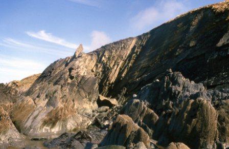
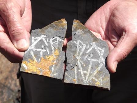
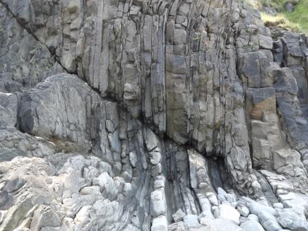
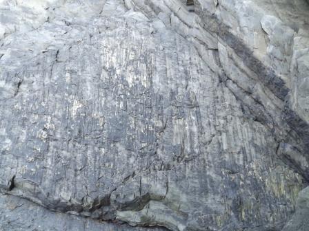
Strumble Head. G.R. SM895413 sheet 157 St. David's and Haverford West. Take the A487 towards Fishguard until you reach Goodwick. Look out for turning on the right signposted to Strumble Head and follow the minor road until you reach high ground with the sea on your right and the lighthouse ahead of you. Roadside parking is available. Make your way to the east over rough footpaths towards the sea where an extensive outcrop of pillow lavas of the Fishguard Volcanic Group (Strumble Head Series) can be seen (picture 11). This locality is not one in the guide books but is very accessible and takes less time to reach. However care is necessary because of steep, potentially slippery slopes over the rocks. The pillows are well developed and can be used to determine way up as later pillows sag into gaps between adjacent earlier pillows (picture 12). Good radial jointing can be seen in individual pillows which are basaltic in character (picture 13). The originally glassy rims have recrystallized. Some of the pillows show good vesicular texture suggesting eruption in fairly shallow water. Some fine grained mudstone / shale sediment occurs within the pillow sequence. The sequence dips to the north. A lava flow or thin sill may be present on the east side of a gully.
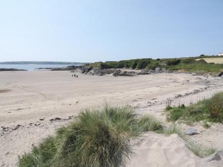
St Non’s Bay was not visited on this occasion but similar rocks to the southern end of Whitesands Bay can be seen with Precambrian volcanics followed unconformably by basal Cambrian conglomerate and then sandstone due to better sorting over a longer period of time (picture 14).
Detail for localities for Pembrokeshire Field Trip day 2
New Quay Sands. G.R. SN390600 (Sheet 145 Cardigan). Follow the A487 from St David’s and Fishguard through Cardigan to the turning on to the A486 to New Quay Sands. There is parking in the town above the Harbour. Go down to the beach to the north of the Harbour where there are good exposures of Silurian Aberystwyth Grits (Llandovry/ Wenlock age). A variety of excellent turbidite features can be seen with a number of sedimentary structures including graded bedding (picture 15), flute casts and sole marks, convolute bedding. The greywacke sandstone units are inter-bedded with mudstone/ shale that has developed a slatey cleavage due to the effects of the Caledonian Orogeny and helping to determine way up (picture 16). The thickness of the units varies as does the proportion of sandstone to mudstone.
Also on the beach there is clear evidence of Caledonian tectonic features with a good example of an eroded anticline with clear NE/SW strike (picture 17). There is some evidence of faulting too
(picture 18).
Figures C summarise the environmental conditions in which the Aberystwyth Grits were deposited. (Derived from BGS British Regional Geology. Wales.)
Further features can be seen around New Quay Head to the north of the harbour, access being dependent on tide conditions. To the south of the Harbour walking south on the beach to around GR SN 392596 exposures of glacial moraine deposits can be seen.
Return to cars and take A486 and A487 to Aberaeron G.R. SN450625 OS Sheet 146 Lampeter and Llandovery. Turn left down to sea front BEFORE the river (Afon Aeron). Walk south to prominent headland where further examples of Aberystwyth Grit features can be seen including evidence of Caledonian structures including asymmetric folds including the monoclonal fold illustrated here (picture 19) and faulting with slickensides (pictures 20 & 21). Again access depends on tides.
Detail for localities for Pembrokeshire Field Trip day 3
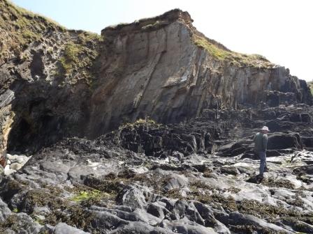
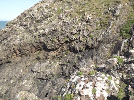
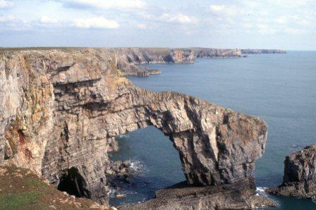
Green Bridge of Wales and Elegug Stacks, Castle Martin. G.R. SS 925945 O.S. Sheet 158 Tenby. Take the B4319 from Pembroke to Merrion and take right turn onto firing range signed to Stack Rocks. Follow the track to the parking area. Views are accessible over the coast with cliffs 50m high in folded Carboniferous Limestone. Spectacular coastal scenery with stack and arch coastal landforms can be seen (picture 22). Look out for corals in the limestone. Note the flat surface inland from the coast which is a marine planation surface formed around 5 m.a. ago during the Pliocene. The limestone exposed in this area is the Pen-y-Holt Limestone Formation. (Figure D is from Folds, Faults and Fossils: exploring geology in Pembrokeshire by John Downes.)
Return to the B4319 and retrace your steps and look out for signs to Stackpole Quay.
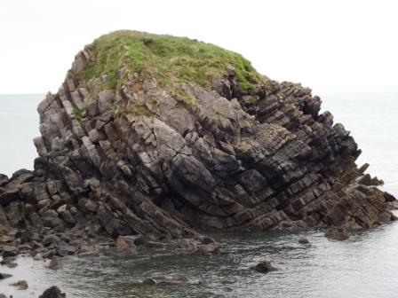
Stackpole Quay G.R. SR 994958 O.S. Sheet 158 Tenby. Parking is available above the Harbour in the National Trust car park where there are also toilets and a cafe. Complex folding and faulting has occurred in the Carboniferous Limestone strata. Again look out for corals (colonial Lithostrotion and solitary Caninia (picture 23) – both rugose corals) as well as brachiopods in the limestone.
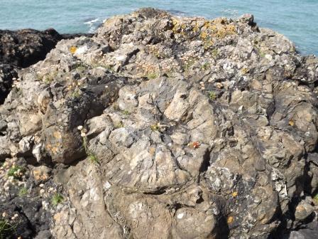
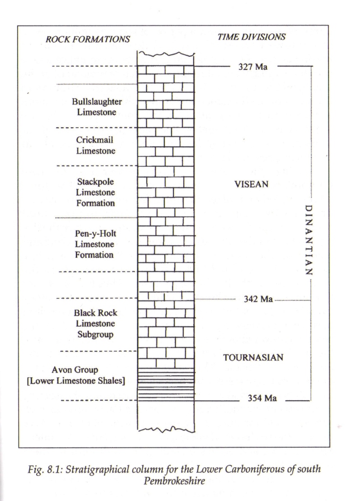
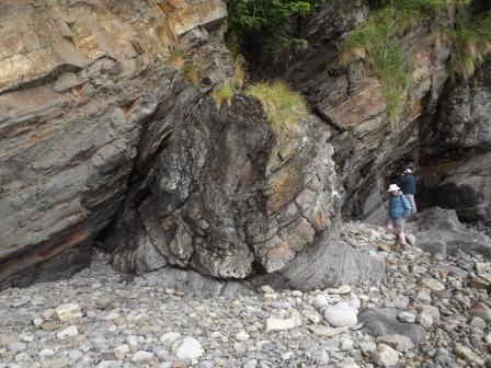
On the north side of the harbour the Pen-y-Holt limestone dips at around 50 NE. The limestone has chert nodules perhaps in some cases precipitated in burrows. Also some of the corals have been replaced by chert. A major dextral tear fault runs more or less N/S through the area causing the strata on either side to be displaced laterally. There is further interest about 200 m to the north where there is a second bay, Middle Cove, where a fine synclinal fold is exposed on an isolated ‘island’ in the middle of the cove. (picture 24).
Return to the B4319 and follow it west to Freshwater West where parking is available overlooking the beach.
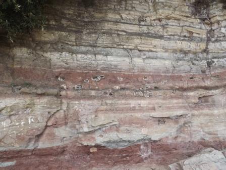
Freshwater West G.R. SR884997 O.S. Sheet 158 Tenby. There are good exposures of the O.R.S. succession going up into the Carboniferous Limestone to the south (although this may be inaccessible as it is in the firing range). Further north Silurian rocks can be seen but these are often concealed by beach sediment (picture 25). At low tide the strike of the rocks is apparent more or less E/W with a steep dip to the south. (Figure E is from Folds, Faults and Fossils: exploring geology in Pembrokeshire by John Downes.)
Above the Silurian shales (to the south) coarse breccio-conglomerate can be seen with a range of clast size, shape and composition (picture 26). Good examples of sedimentary structures such as cross bedding can be seen especially in the cobbles that form the beach below the car park which are useful for determining way up (picture 27). On the S side of Little Furzenip red mudstones are exposed with well-developed calcrete horizons in the Moor Cliffs Formation (picture 28). These are calcite rich horizons developed from evaporating ground water in a hot savannah climate with alternating wet and dry seasons (similar to the Sahara margins in West Africa now). Note from the succession above these rocks are dated as being Silurian despite being Old Red Sandstone in character. Further south the Freshwater West Formation is exposed with red mudstone and sandstone units rich in ferric iron formed in an oxidising environment. Some layers have a green colour where the ferric iron has been reduced to ferrous iron. The sediments were deposited from meandering streams and show fining upward units from conglomerate (point bar deposits), then cross-bedded sandstone succeeded by mudstone with calcrete material (flood plain environment – over bank deposits). Further south there is a risk of unexploded ordnance as you enter the firing range
The sequence of rocks is cut by a NNW/SSE trending fault (Flimston Bay Fault – similar trend to the fault at Stackpole Quay) which is a dextral tear fault with a displacement of around 120m
(picture 29, the white line marks the approximate position of the fault). This is best seen at low tide from the higher ground above the beach.
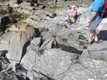
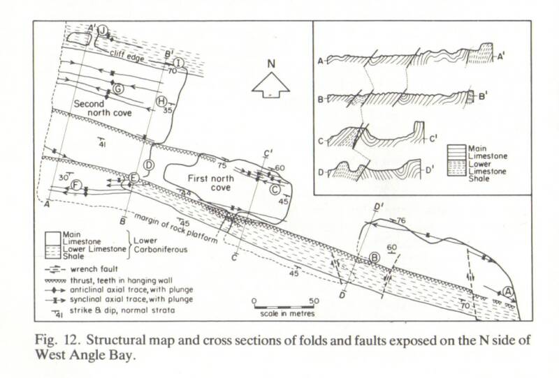
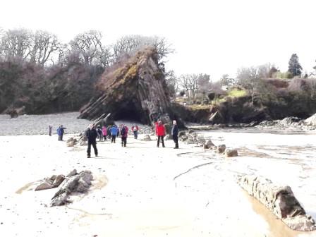
West Angle Bay G.R. SN853033 Sheet 158 Tenby. Follow B4319 northwards to the T junction with B4320 and turn left (west) along B4320 to Angle and continue straight on to car park overlooking West Angle Bay. A large synclinal fold (Angle Syncline) is apparent with strata on the left (south) dipping north and those on the right dipping south (picture 30). The centre of the fold structure is in-filled with sand. The fold has the classic Variscan trend (WNW/ESE). The rocks exposed are the Avon Group (formerly the Lower Limestone Shales) with the Black Rock Limestone to the north although the relationship between these two units is complicated by a thrust fault (B in Figure F)(picture 31) with slickensides (E in Figure F). Walking north and west over the rocks and wave cut platform a number of well-developed folds can be seen including a couple of periclines (G in Figure F), dome shaped folds that close to the E and. W
(pictures 32 & 33). The limestone often develops tension gashes due to shearing and these are filled with calcite (C in Figure F). The limestone also contains corals (Zaphrentis), crinoids and brachiopods. Trace fossils can also be seen (picture 34). Some rather curious radial joint patterns can be seen and these relate to use of explosives while quarrying the limestone in the past (picture 35). Some smaller fold structures are developed on the limbs of the larger folds (picture 36).
(Figure F is derived from Geological Excursions in Dyfed, South-West Wales. Bassett M.G. (Ed.). National Museum of Wales).
Detail for localities for Pembrokeshire Field Trip day 4
Saundersfoot. G.R. SN 138047 O.S. Sheet 158 Tenby. Take the A4139 from Pembroke to Tenby and the A478 towards Saundersfoot via the B4316. Park in Saundersfoot and walk to the harbour. On the south side of the harbour are exposures of Lower Coal Measures of the Upper Carboniferous. The rocks consist predominantly of sandstone and mudstone units with some coal seams. Apparently Saundersfoot was the centre of an important coal trade from the Pembrokeshire Coalfield in the 19th and early 20th C (peak production 1913). The strong deformation in the area caused the coal to be increased in ‘grade’ to anthracite (>95% carbon). The section to the south of the town has well developed Variscan structures with a typical WNW /ESE strike.
The wall on the south side of the harbour is the almost vertical limb of an asymmetric anticline with a gentle southern limb (picture 37). Farther south there are a number of folds cut by thrust faults (picture 38). Shearing tends to occur associated with coal seams which have limited competence compared with the sandstone and fireclay (fossil soil below the coal seams) units.
One of the most spectacular structures is the Ladies Anticline around 500 m. south of the Harbour (picture 39). The fold is an asymmetric structure with an eroded core where shale is weaker and was also crushed during the tectonic events. The fold has a steeper limb to the north because of the maximum pressure from the south and is an excellent example of a tight angular fold. The fold is best seen at low tide from the beach where the strike and dip of the beds is very clear. A complementary syncline can be seen to the north although this is largely eroded away and the core of fold filled with beach sediment. Another 200 m. farther south is a major over-fold in massive sandstones thrust over a sequence of coal bearing units. Shales are present and some of these contain the freshwater mussel Carbonicola.
If time allows return to Saundersfoot and follow signs for Amroth GR SN 161070. Follow the beach for around 150 m. SW of Amroth where the Coal Measures are affected by a number of complex fold and fault structures (thrusts due to crustal shortening during the Variscan Orogeny)
(picture 40).
Detail for localities for Pembrokeshire Field Trip day 5
From St David’s follow A487 to Haverford West and then A40 until you reach the M4. Follow the M4 to junction 33 and take the A4055 to Barry Island. Parking is possible near to sea front. Once parked, walk west on to the grassy area and make for Friars Point. (ST11660 O.S. sheet 171 Cardiff and Newport.) Barry Island is an SSSI. Here the strata demonstrate an angular unconformity with late Triassic breccia resting on dipping Carboniferous Limestone (picture 41). (The dip is 40 S and strike more or less E/W). In the Carboniferous Limestone crinoid debris can be seen as well as corals. The breccia is coarse with large locally derived clasts of Carboniferous Limestone. On the east side of Friars Point above the beach (Whitmore Bay) there is a cliff of near horizontal upper Triassic red and green marls (Branscombe Mudstone Formation formerly known as the Keuper Marl with nodules of gypsum often affected by solution and in some cases replaced by calcite. These nodules are sometimes called potato stones (picture 42).
o
o
o