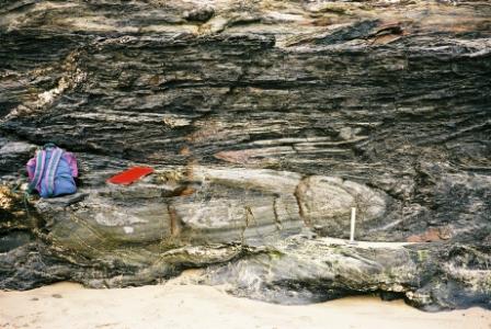
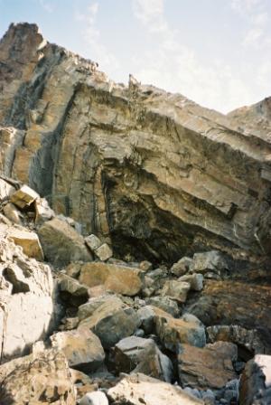
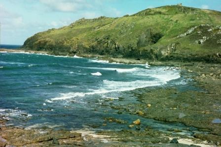
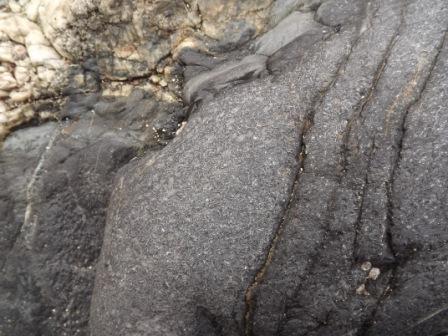
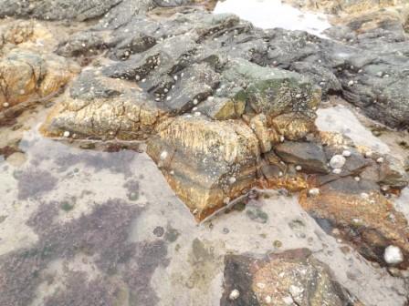
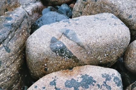
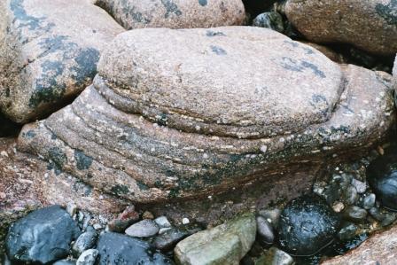
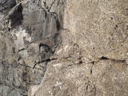
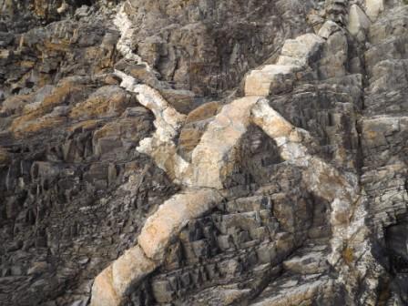
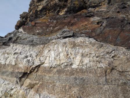
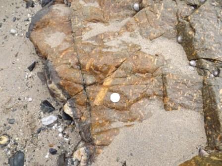
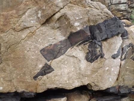
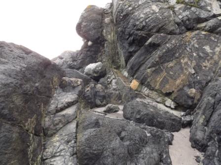
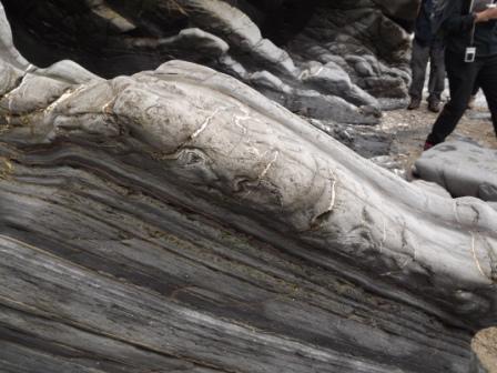
During the visit to Cornwall a wide range of geological features will be seen. The country rocks are formed of Devonian and Carboniferous sediments that were deposited at the edge of the Rheic Ocean. The closure of this ocean at the end of the Carboniferous caused the Variscan (Hercynian) Orogeny. The sedimentary rocks, mostly of turbidite origin were intensely folded as can be seen at Godrevy Point GR SW 580433 (picture 1), Gunwalloe Church Cove and along the north Cornwall coast between Boscastle and Hartland Quay (picture 2). Associated with this orogeny was the large scale intrusion of granitic magma which formed the Cornubian batholith which extends from Dartmoor to the Scilly Isles and beyond. This has been dated as being approximately 281 m.a. The Land’s End Granite is one of the stocks or bosses that form the batholith and is one of the best exposed as the contact between the granite and the country rock, locally known as killas, is well exposed along the coast, for example at Cape Cornwall and Porthmeor Cove (picture 3). Various dykes, sills and inclined sheets can also be seen, probably most spectacularly exposed at Megiliggar Rocks north of Porthleven. A number of igneous textures can be seen in the granitic intrusions. These include porphyritic, flow, orbicular textures and well developed euhedral feldspar crystals. Metalliferous mineralisation (tin and copper) occurred associated with the intrusion of the granite magma but evidence of this is limited except for the large number of ruined engine houses that dot the landscape. Quartz tourmaline veins are the telltale sign of this mineralization. One of these veins can be seen at Mousehole (picture 4).
Associated with the closure of the Rheic Ocean, the Lizard ophiolite complex was emplaced. This shows a range of igneous and metamorphic features exposed around the coast of Britain’s most southerly point. The geology is complex and the relationships difficult to interpret (boundaries between units are mostly tectonic). However the original sediments and igneous rocks that formed the ocean crust, now much altered, are exposed and provide an interesting study (picture 5)More recent geological processes are related to Pleistocene conditions and periglacial head is well developed around the coast. At Godrevy there is a good example of a raised beach (Ipswichian Interglacial) (picture 6) and at Praa Sands there is also a 2000 year old peat deposit (Holocene). The flat surface of the Lizard is also possibly a Miocene erosion surface.
The itinerary relates to areas 1, 2, and 5 on map 1 (Hall, A. 1994)
The Variscan granites were intruded at the end of the Carboniferous period following the closure of the Rheic Ocean. The dates of the granites range from 290 to 270 million years but some of the dates represent post-orogenic mineralization rather than the granite intrusion itself.
Tides are critical at most of the localities and low spring tides should be chosen to ensure access and safety. Generally low tides occur around lunchtime associated with spring tide events.
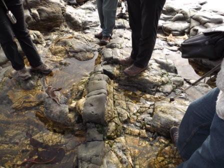

1 Godrevy
flat lying fold
2 Hartland Quay
overturned anticline
3 North of Porthmeor Cove
granite contact
4 Mousehole
schorl dyke
5 Rosenithon
basalt dyke cutting gabbro
6 Godrevy
raised beach over
Devonian rocks
General information & Geological History
Cornwall Field Trip Itinerary
Grid references refer to Ordnance Survey maps 203 (Lands End) and 204 (Lizard). Localities can be visited in different order to make best use of light and tides although the order below is recommended. Tide information is for Newlyn and is more or less ideal for the visit. Spring tides are essential for a number of the localities and in west Cornwall these provide a low tide around lunch time.
Day 1. Friday 9th March
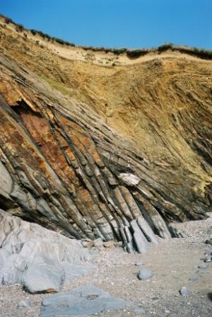
Travel to Penzance. If you have time a detour via the north Cornwall coast to Bude and surrounding area is worthwhile to see the amazing Variscan fold structures. Further information is available for those interested.
Day 2. Saturday 10th March
Mousehole G.R. SW 468256 shows the contact between killas (Devonian country rock) and the Lands End granite; hornfels is developed at the contact. There are also quartz tourmaline rich dykes (schorl rock) (picture 4).
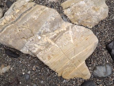
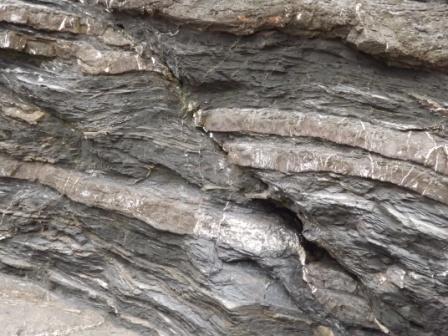
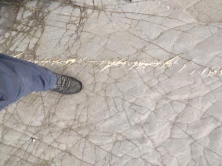
On the south side of Mousehole Harbour there is a good section shows the contact of the Land’s End granite with the Devonian Mylor ‘Slates’. These country rocks are generally termed killas and were originally probably turbidite sediments. Most of the sediments in the area have many quartz veins due to, what is termed, sweating out. The veins start and stop locally within the rock and the material must be from the original quartz rich sediments. This process can occur at quite low temperatures and doesn’t involve metamorphism (picture 7 which shows a similar feature at Gunwullowe Church Cove).
The roof of the granite undulates and so the contact can be seen in a number of places and a well developed chilled margin is apparent as well as xenoliths of country rock (picture 8 and 9).
The contact metamorphism is also variable due to the varying nature of the country rocks and the undulating roof of the granite. The rocks in places are spotted showing evidence of thermal (contact) metamorphism. A dyke of quartz tourmaline (schorl) rock can be seen as well as granitic dykes and some evidence of faulting displacing the dykes. Mousehole is best studied on a falling spring tide.
Lamorna Cove G.R. SW 450240 Giant granite is exposed with large feldspar phenocrysts (megacrystic), and is part of the Lands End stock/batholith. Various textural features are apparent with well developed euhedral crystals (picture 10) and evidence of flow textures as well as xenoliths in loose boulders on the beach. Good examples of periglacial deposits (periglacial head) can be seen above the beach. Granite coastal scenery with castellated cliffs is well developed due to the jointing in the granite (picture 11). This locality can be studied at any state of the tide.
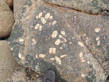
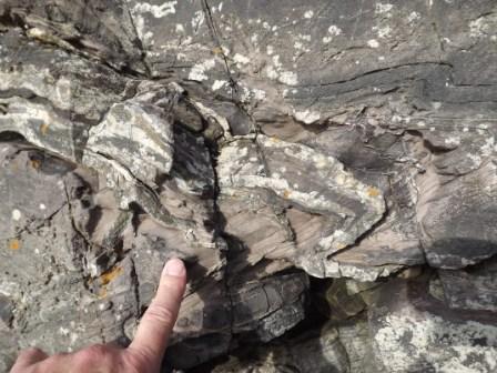
Cape Cornwall, Porth Ledden (picture 12) G.R. SW 352318. At Cape Cornwall a low tide is essential to see the features. There is an extensive wave cut platform with chiastolite ‘slate’. The needles are very small and careful searching is necessary to find them. There are also spotted rocks. Both the chiastolite slate (see picture 13) and spotted rocks (see picture 14) are due to contact metamorphic effects, hence the random orientation of the chiastolite crystals. The best locality to see these features is close to the base of the slip way. Moving north across the wave cut platform there are granitic inclined sheets, some with excellent pegmatite with large feldspar crystals growing into the intrusion (see picture 15). There is also evidence of orbicular granite (picture 16), the origin of which is difficult to explain. Most texts recognise its existence without explaining it! Within the main granite there are excellent examples of flow texture, euhedral feldspar crystals (picture 17) and evidence of potash metasomatism with feldspar crystals having grown in xenoliths due the movement of potassium ions from the magma into the xenoliths (see picture 18). Flow texture is also well developed in the granitic rocks (picture 19). There is also evidence of multiple intrusion processes. Some radiometric dates measured at Cape Cornwall are around 270 m.a. but it is thought that this is for late stage alteration and the granite was intruded around 10 m.a. earlier
Porthmeor Cove G.R. SW 425375 Porthmeor Cove is reached by a fairly lengthy walk but is worth the effort. Care must be taken with the steep approach and also care should be taken with large waves breaking on the lower rocks.
The country rock above the steep path down onto the rock surface shows good evidence of complex micro-folding (picture 20).
The roof of a cupola (a dome like rise in the roof of the granite) can be examined with layers of aplite and tourmaline rich pegmatite (picture 21). There is clear evidence of the chilled margin and well as porphyritic micro-granite (picture 22). Other interesting textural features include a Maltese cross twinned feldspar. Inclined sheets and dykes of granitic material cut the country rock showing evidence of more than one period of injection (picture 23).
This is an SSSI so no hammering.
Map 2 from Hall, A. 1994
7 Gunwallowe Cove
sweating out of quartz


8 granite contact
with chilled margin
9 xenolith

10 euhedral feldspar and porphyritic texture
11 castellated cliffs
Day 3. Sunday March 11th
Praa Sands G.R. SW 575282 An elvan dyke (quartz porphyry) cuts killas. Also Holocene peat deposits are exposed. On arriving note should be taken of the rock armour much of which is of local provenance and shows interesting textural features in the granitic rocks. The main feature at Praa Sands is a dyke at the far NW end of the bay in the area known as Sydney Cove. The dyke runs NE/SW and is around 20m wide. It is exposed in the beach but not in the cliffs where there are Pleistocene periglacial head deposits. The granitic dyke is quartz porphyry (local term is elvan) with feldspar phenocrysts which in places show a well developed flow texture (orientation of the crystals) (picture 24). The dyke has a well developed chilled margin and probably shows evidence of more than one intrusion. Contact metamorphism of the country rock (killas) has also occurred.
In the middle of the bay at the back of the beach there is a peat deposit formed around 1850 years B.P. which probably formed in a lake behind a former dune system.
Megilligar Rocks G.R. SW 612266. There are sills of pegmatite and aplite cutting the killas as well as chiastolite slate occurs below the lower sill. A low tide is also essential to access this site which is to the north of the beach access below Tremearne Farm. The sills are of aplite and pegmatite (picture 25) and with luck large tourmaline crystals can be found. These are best found in pieces of pegmatite in the rock pools at low tide. There also excellent examples of xenoliths of Mylor ‘Slates’ incorporated in the sills (picture 26) as well as evidence of the pneumatolytic alteration of the granitic rocks. This is an SSSI so no hammering on in-situ material. A date of around 270 m.a. has been measured for the sill material
Jangye-Ryn, Gunwallowe Church Cove G.R. SW 659205. Intensely folded killas (meso scale folds) in Gramscatho Beds can be seen. Gunwalloe Church Cove demonstrates some excellent evidence of the tectonics associated with the Variscan Orogeny. The sediments are of the Porthscatho or Gramscatho Formation. They were originally turbidites and the inter-bedded mudstones and sandstones (picture 27) have been affected by low grade regional metamorphism to form slates. There is good evidence of over-folding (picture 28) and way up can be determined by sedimentary structures (picture 29). Unfortunately erosion of the cliffs over the past few years has destroyed some of the best structures. There is good evidence of relationships between bedding and cleavage as well as small scale faulting and tension gashes (picture 30).
The Lizard is recognised as an ophiolite complex, a piece of ocean crust obducted rather than subducted during the continental collision process associated with the Variscan Orogeny.
Kennack Sands G.R. SW 734165 sheet 204. At Kennack Sands serpentinite with gabbro and basalt dykes intruded as well as evidence of mineralisation linked to the alteration of the peridotite to serpentinite can be seen. Talc and asbestos minerals can be collected. There is also the Kennack Gneiss. Interesting age relationships are apparent when studying the basalt dyke and gabbro inclined sheet (picture 31).
Map 3 from Hall, A. 1994
Other localities below are also worth visiting if time allows.
Pollurion Cove (near Mullion) G.R. SW 668188 contact between Gramscatho Beds and Lizard Complex (hornblende schists), the boundary is the Meneage Fault.
Porthoustock, Manacle Point Sheet 204 G.R. SW 810212. Gabbro with basalt dykes.
Coverack G.R. SW 782185 bastite serpentinite and gabbro-troctolite with basalt and gabbro dykes.
References
Geologists’ Association Guide No 19. West Cornwall. A Hall. 0 900717 57 2
Geological Conservation Review Series. Igneous Rocks of South-west England. Floyd, Exley and Styles. 0 412 48850 7
BGS Geology of the country around Penzance. (sheet 351,358). 0 11 884388 5.
Cornwall’s Geology and Scenery. An introduction. C.M. Bristow. Cornish Hillside Publications. 1 900147 00 9
Geology of Cornwall. Edited by Selwood, Durrance and Bristow. University of Exeter Press. 085889 432 0
Alan Holiday April 2012
(from whom further details can be obtained)
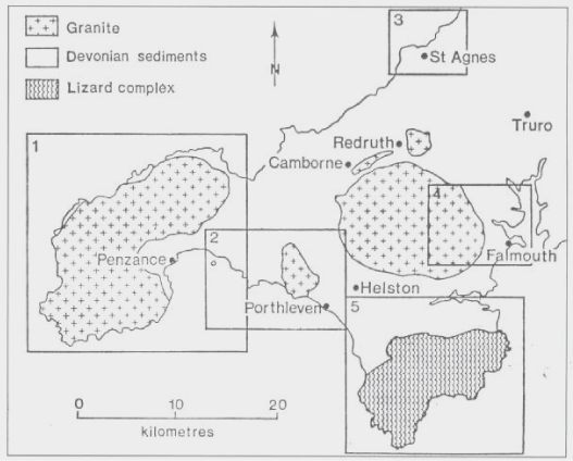
Localities map 1

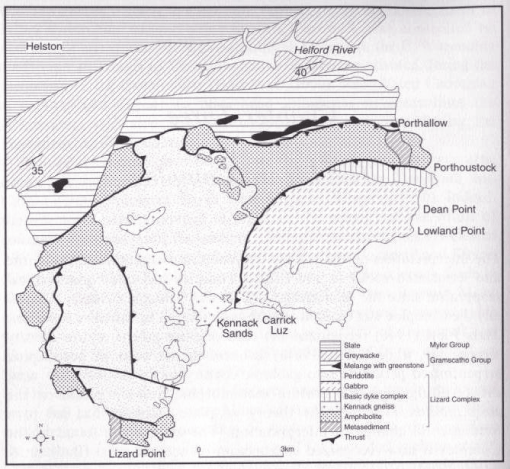
Map 2
12 Porth Ledden
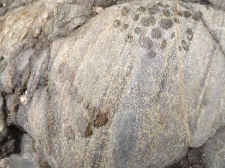
13 chiastolite slate
14 spotted rock
15 pegmatite sheet
16 orbicular texture
17 euhedral feldspar
phenocrysts
18 xenolith with feldspar crystals cut by later intrusion
Mousehole
Cape Cornwall
19 flow texture in granite
20 microfolding in killas
21 granite contact with
phenocrysts and maltese
cross twin
22 inclined sheet cut by
granitic dyke
Porthmeor Cove
23 pegmatite and aplite
at top of cupola
Praa Sands
24 feldspar phenocrysts
in elvan dyke
Megilligar Rocks
Gunwallowe Church Cove
25 aplite and pegmatite
with feldspar phenocrysts
26 killas xenolith
in granitic sill
Kennack Sands
31 basalt dyke and gabbro inclined sheet
Map 3
27 reverse fault in interbedded sandstone and slate
28 over fold
29 convolute bedding showing strata are inverted
30 tension gashes
Lamorna Cove
Dorset Geologists' Association Group
Penzance Field Trip
March 9-11th 2012
Click for higher resolution photos, click 'close' at base of photo to return to this page