C RWG
O
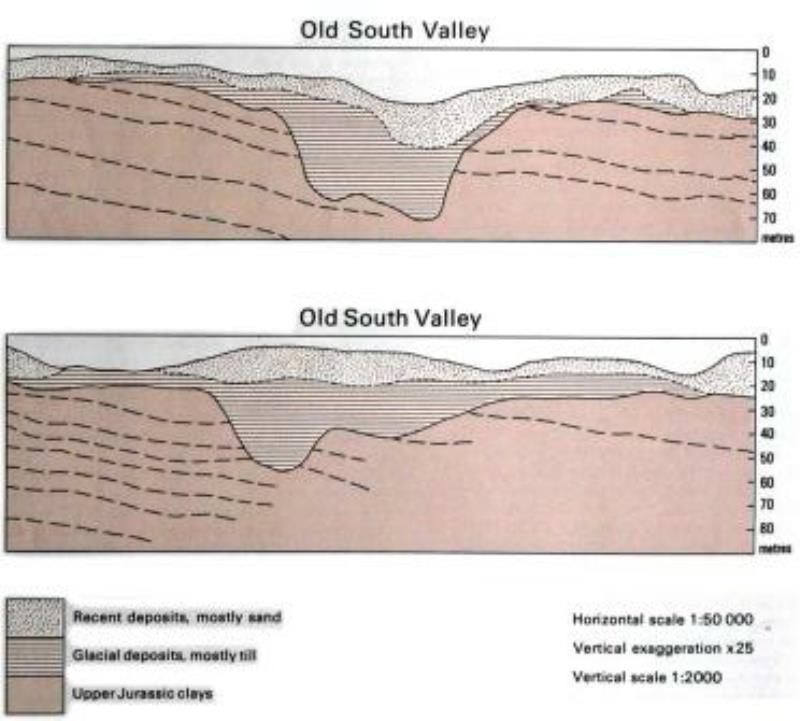
The proposed barrage across The Wash from Hunstanton, Norfolk to Skegness, Lincolnshire was originally designed to provide water storage, tidal power and a deep-water port. This was rejected on cost and environmental grounds and replaced by a series of water-storage bunds in the southern part of The Wash that would contribute to the supply of the Essex and Greater London area via a series of water-transfer tunnels. The onshore part of the site-investigation required a detailed knowledge of the geological succession and structure of an area of 25 x 35 km to a depth of 100 metres in order to determine the routes most likely to be favourable to the use of a soft-ground tunnelling machine. The whole of the area was known to be underlain at depth by Upper Jurassic mudstones that would provide a good tunnelling medium, but these were everywhere overlain by the thick (up to 30m) Recent Deposits of Fenland and, locally, by heterogeneous glacial deposits.
Seismic reflection surveys in The Wash and along the River Great Ouse indicated the presence of a concealed pre-glacial valley system down to depths of 70m below Ordnance Datum that was infilled by non-reflective deposits. These were shown by cored boreholes to comprise laterally variable successions of boulder clay (Anglian till), glacial sand and gravel, and varved clays. The till varied from stiff reconstituted Jurassic mudstone with a few small stones to loose chalk-rich debris, and the sand and gravel from loose sand to loose gravel. The varved clay was lithologically relatively consistent, but poorly consolidated and weak. None of these materials were a suitable medium in which to tunnel with taking special (i.e. expensive) precautions.