Explore the geology and terrain of Dorset
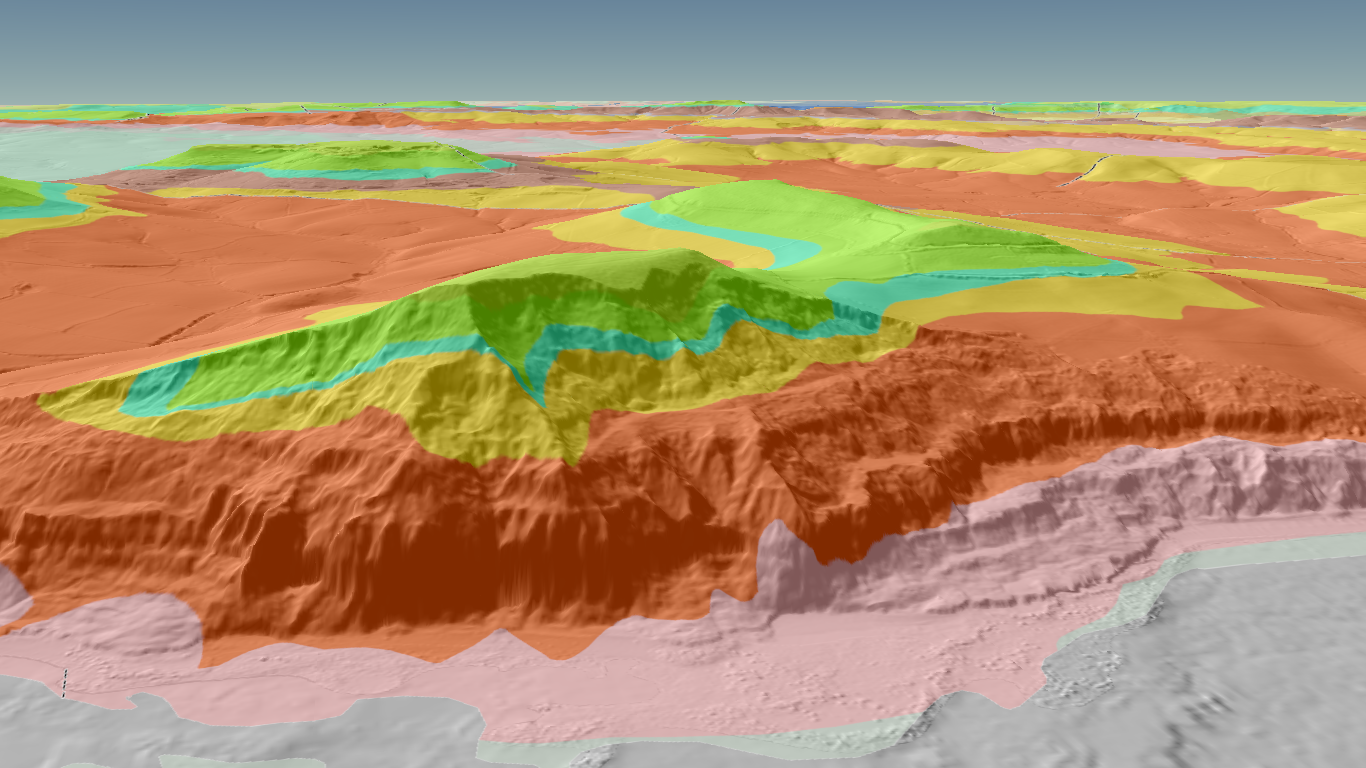
New! 3D Digital Terrain Model
Select the image of Golden Cap (below) to open the GeoFeature 3D DTM in a new browser window
2.5D Digital Terrain Model
Below is a less resource-hungry interactive map. This may work better depending on your platform and internet bandwidth.
This Hillshade Digital Terrain Model (DTM) collates information from a range of authoritative map sources and may take a while to load. Please, be patient…
Map controls:
Mouse-click and drag, to pan the map
+ Zoom in, – Zoom out
Layer menu to show/hide different map layers, adjust opacity (transparency) and order.
[ ] Display the map in full screen mode (recommended). Return to this page by reselecting the icon or pressing [Esc] on your keyboard.
Search for a specific location.
The underlying hillshade map layer is largely derived from high resolution (typically, 1m) LiDAR Digital Terrain Model (DTM) from the UK Environment Agency. This provides around 2/3 coverage of Dorset, and is more extensive for coastal and low-lying areas. Full coverage should be available in the next few years. The remaining hillshadeis derived from lower resolution (25m) data from the Copernicus Digital Elevation Model over Europe (EU-DEM) and the Ordnance Survey DTM5 (5m resolution). The Hillshade map tiles have been generated using QGIS
The hillshade accentuates the landscape and geomorphology; including coastal erosion features, quarries and archaeological features such as hill forts, round barrows, and strip lynchets.
The geology layers are provided by British Geological Survey (BGS) Web Map Services (WMS). As you zoom in, the geology layers switch from a 1:625 000 (DiGMapGB-625) overview to the more detailed 1:50 000 (DiGMapGB-50) scale. If you click on the maps, relevant geological details (Group, Formation, Member, Bed etc) are displayed.
Similarly, as you zoom in, Ordnance Survey 1:50 000 (Landranger) and 1:25 000 (Explorer) map layers are progressively displayed, via Bing Maps
From the layers menu (top-left), detailed historic Ordnance Survey maps of Dorset and adjacent counties may be displayed. These are reproduced, for educational, non-commercial use, with the permission of the National Library of Scotland
Details of other map layer providers can be found in the Data attribution link at the bottom of the terrain map.
Location coordinates are displayed by hovering your mouse-pinter over a position. These are given as decimal Longitude/Latitude and as British National Grid Reference. The accuracy should be around 2m, comparable to that of the map layers and consumer GPS devices.
As an alternative, you can also view 2D geological maps in the BGS Geology of Britain viewer.
Older versions of geological maps and sections may be freely viewed via the BGS maps portal
There is also a BGS Geology of Britain 3D (Beta version) viewer. This has a lower terrain resolution than the DGAG 3D map, above, but includes additional borehole information and geological cross-sections (fence diagrams).
Google Maps also have some high resolution 3D aerial imagery, generated via stereophotogrammetry, along the coast between Poole Harbour and Barton on Sea and the section of the World Heritage Coast between the Fleet and Kimmeridge Bay.